MBCL
The Mount Baker Climate Laboratory (MBCL)
Mountain climate science co-created by citizen and professional scientists
Our mission is to inclusively and openly answer climate questions about Mount Baker relevant to local and regional communities.

WHAT IS THE MBCL?
This is a collaborative project in which citizen scientists and professional scientists co-create understanding about the climate of Mount Baker using a combination of in situ and satelitte measurements. We ask provide data and ask questions relevant to the hydrologic health and welfare of this important environmental system.
How does the MBCL work?
The MBCL is a result of ongoing partnerships between several organizations (Table 1). Its foundation comes from ongoing measurements of temperature at nine sites along the southern ascent of Mount Baker. These temperature measurements are made in distributed arrays from which we can derive much more than simply an understanding of local temperature patterns and trends. The arrays of temperature
Table 1. MBCL Institutional Partners
| Institution | Role |
|---|---|
| Adventure Data | In situ snow measurements |
| Earth and Space Research | Lead institution, data analysis, citizen scientist education |
| Lakeside School | In situ temperature measurement deployment and collection |
| United State Forest Service | Permitting and use of hydrological data |
CONTRIBUTORS
Click here for a list of our contributors.
SCIENCE QUESTIONS (please help us ask more!)
- What are Mount Baker temperatures and lapse rates?
- Are important ecosystem thresholds being reached?
- How have the lapse rates changed over time?
- How are these variables represented in Reanalysis or other products?
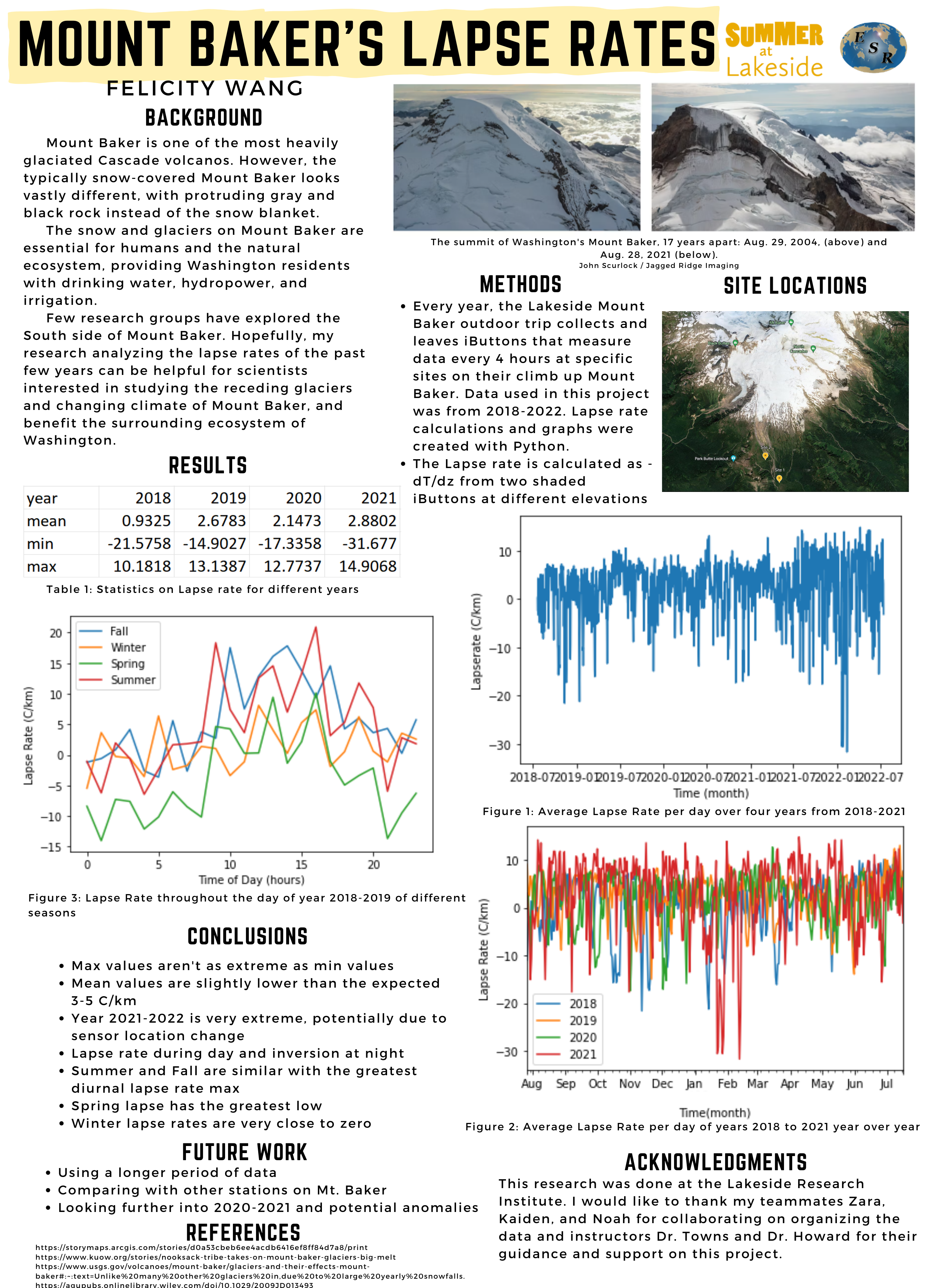
- See this poster by Felicity W. here
- What are the temperature impacts on the ecosystem of Mount Baker?
- click here for more information
- What is the seasonal snow extent on Mount Baker?
- Does this change interannually?
- What is the seasonal snow height at Schriebers Meadow, on Mount Baker?
- Can we connect this seasonal snow height to other more long-term measurements (e.g., regional SNOTEL stations)?
DATA
There is a lot that goes into deploying, collecting, cleaning, and munging the data for analysis. See here for a description of this process, along with links to figures and code.
Take a look at the interactive data we have curated so far. Inspired? Read on!
ANALYSIS
Some initial analysis has been performed on these data already. See below for examples of co-creation between Citizen Scientists and Professional Scientists.
Mount Baker Snow Depth Retrievals
Noah L. (Citizen Scientist) led a short study successfully retrieving snow depth at Schriebers Meadow from temperature data collected on a 2.5 m snag. See his work here.
Mount Baker Snow Extent Retrievals
Building on a series of other Citizen Scientist work (Tanvi G., Kimberly L.), Zara Z. (Citizen Scientist) developed an extended time series of snow extent on the southern side of Mount Baker as a function of elevation. See her work here.
A Summary of the MBCL project: Motivation, Design, and Early Results (2022)
Linked here is a presentation summarizing the MBCL as of April 2022. Included in this presentation are some motivation, design, and early results including snow extent retrievals and an extension of the Schriebers Meadow time series using routine regional data trained on a supervised machine learning OLS model. Citizen Scientists: Tanvi A., Tea F-S, Tanvi G., Kimberly L.
An Update on the MBCL: Design, Partnerships, and Results (2023)
Linked here is a presentation summarizing the MBCL as of December 2023. Included in this presentation are the design, partnerships, and updated results. The update results include improved snow extent and snow depth retrievals, as well as a summary of the extension of the Schriebers Meadow time series using routine regional data trained on a supervised machine learning OLS model. Citizen Scientists: Tanvi A., Tanvi G., Noah L., Zara Z.
Mount Baker Ecosystem Thresholds
Felicity W (Citizen Scientist) has processed data from Schriebers Meadow to understand whether and for how long local flora are exposed to temperatures beyond their temperature established stress thresholds. See here for more.
Tricky installations
Two of the trickiest installations are at the Crater Rim and the Summit. Read about what to do if you find one of those installations here.
YOU CAN CONTRIBUTE
If you are interested in contributing or have any questions, please reach out to michael.town@esr.org.
LAND ACKNOWLEDGEMENT
We respectfully acknowledge that we learn, live, reflect, teach, and observe on the ancestral homelands of Tribes, Bands, and First Nations, including Coast Salish, Lower Skagit, and Upper Skagit.
We would like to express respect and gratitude for our Indigenous neighbors for their care and protection of our shared lands and waterways and celebrate the resilience and strength that Indigenous peoples have shown and continue to show.
To acknowledge this land we share, study, and value is to critically reflect on a history that includes disease, displacement, violence, and loss of land, and to recognize our place in that history. We offer this acknowledgement as an important step in honoring the relationship with land we share, and a call towards further learning and action.
Sponsors
This work has received generous support from Ballard Data Science, The Douchas-Nolan Fund through the San Diego Foundation, and Earth and Space Research
If you would like to donate, please click here